Yesterday was the City2Surf, and I’m happy to say it went pretty well. Jacqui was also doing it, but she was planning to walk most of it with friends and was starting at the back of the pack, at least 30mins behind me, so I ventured into the city alone to get myself organised. Dropped my ‘keep-warm’ clothes off to get taken to the finish, and queued for about 15mins for the last minute toilet, then made my way over to my start group. It was a bit warmer than I’d expected which was good as I was standing around for about half an hour before the start.
As mentioned previously, I’d managed to get myself in to the fast start group which had a cut-off time of 1:15:00, but I was hoping to crack 1:10 for an average of 12km/h. I hadn’t done any training on hilly courses so was a bit unsure of how I’d get on, so I decided to take it relatively easy until the top of Heartbreak Hill (around 8km) and then see how I felt, and I also decided to start at the back of my group as I was likely to be one of the slower members and this would allow me to stay out of everyone’s way and make it easier to settle into my own pace.
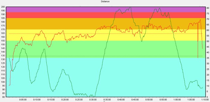
I’d loaded my Shuffle with the metronome MP3s I used on Friday, two 175bpms and a 180bpm, so once the gun went and I crossed the line I hit play, started my HR monitor and I was off. The graph up top gives and idea of how things went. The red line is my heart rate and the green is the altitude, so you can see the course is quite hilly.
As expected, my group slowly pulled away from me at the start, but I synced with the ‘tick, tock’ in my ear and just cruised along at my own pace. There were quite a few people lining the streets to watch the race, and The Golden Sheaf had a rock band blasting away from their balcony, playing some Metallica as I ran by. The first couple of hills weren’t too bad and I split 25:19 for the first 5km, or 5:04/km pace, which I was pretty happy with. By this stage I was running along beside the harbour at Rose Bay, approaching the dreaded Heartbreak Hill, the almost vertical line you can see on the above graph. I hit the bottom and just focused on keeping a decent rhythm going and I started passing people who had gone out too fast and were paying the price.
The half-way point at 7km was about half-way up Heartbreak Hill and I went through that in 36:41 (5:14/km). Doubling that gave me 1:13:20 so I figured that I now had no chance of breaking 1:10, but at that stage I just wanted to get to the top of the hill and get all the climbing over and done with! I was also conscious of the fact that once I got to the top of the hill I was on familiar roads that I’d run many times previously when I was living in Vaucluse, and that it was mostly downhill to the finish. I made it into Vaucluse village still feeling good and with my HR coming down after the uphill exertions, so I decided now was the time to pick things up a bit.
Turning onto Military Road at 9km I was still well over 5:00/km pace, so I pushed the downhill bit then rounded the corner facing another uphill. I was getting sick of the uphills at this stage, but once I got to Dover Heights that was definitely the last of them. I missed the 10km marker, but my running was feeling good, despite the onset of a stitch. I jammed my fingers under my ribcage to get rid of it and just kept going. By 11km the downhill pace was taking effect and I was getting close to 5:00/km pace, and I reached 12km in 59:50, taking me under 5:00/km pace for the first time. At this stage I knew I’d break 1:10 so I just kept going and resolved to try to maintain my current pace all the way to the finish when I hit the flats of Campbell Parade.
By this stage I was passing people left, right and centre but still feeling good. I came around the roundabout onto the promenade and could see the finish line, with the clock counting down to 1:10. I knew I had a bit of time in hand as it had taken me some time to cross the start line after the gun went off, but I decided to try to beat the finish clock to 1:10 anyway. The race announcer was shouting encouragement, trying to get everyone in under 1:10 so I just went for it, remembering to stop my watch as I hit the timing pads. That was it. All over and I still felt surprisingly good. HR peaked at 183 across the line.
1:08:03. That was my time by my watch, which I was pretty happy with. I’d knocked off the second 7km (mainly downhill) in 31:22 (4:28/km) and the last two kms in 8:13 (4:06/km), so perhaps I took it a bit too easy in the first half? Official results are published in the paper tomorrow, so I’ll have to wait until then to get my final time.
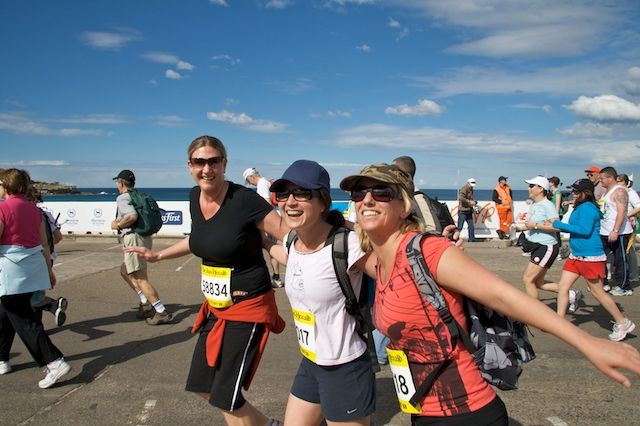
I went home, had a quick shower, grabbed my camera and headed back down to the finish to get a snap of Karly, Jacqui and Debbie in the finishing straight…
After that I was off to Reidy’s for a much-deserved BBQ to compare notes with other runners. Stu and Gareth both managed around 1:07, whereas Adrian was way out in front with a 1:01. Nice work!